Property Record
1101 W Main St, Freehold, NJ 07728
NEARBY LISTINGS FOR SALE OR LEASE
-
-
View all Freehold listings for sale on LoopNet.com
Property Detail
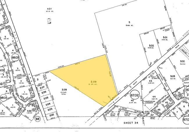
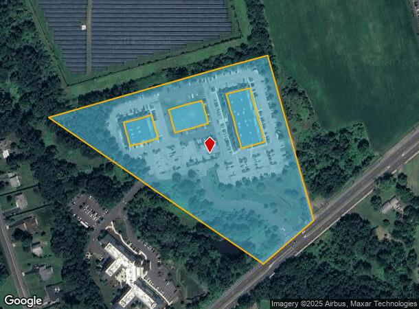
1101 W Main St
New York-Jersey City-White Plains, NY-NJ
Pond View Office Park
17-00086-0000-00002-09
Monmouth
Hospitalpublic
New Jersey
X
2.9
34025C0280F
12.24 AC
0
Western Monmouth
2025
Northern New Jersey
810503
DEMOGRAPHICS near 1101 W Main St
1 Mile
3 Mile
5 Mile
2024 Total Population
5,599
34,245
78,957
2029 Population
5,522
33,782
78,074
Pop Growth 2024-2029
(1.38%)
(1.35%)
(1.12%)
Average Age
44
42
42
2024 Total Households
2,165
12,083
28,233
HH Growth 2024-2029
(1.43%)
(1.56%)
(1.32%)
Median Household Inc
$116,249
$117,224
$117,736
Avg Household Size
2.50
2.70
2.70
2024 Avg HH Vehicles
2.00
2.00
2.00
Median Home Value
$397,597
$483,291
$490,835
Median Year Built
1983
1980
1984
Nearby Places
- Restaurants
- Banks
- Shops
- Fitness
- Groceries
PUBLIC TRANSPORTATION
AIRPORT
Trenton Mercer
DRIVE
WALK
Distance
Trenton Mercer
49 min
33.8 mi
Freight Ports
New York Container Terminal
DRIVE
WALK
Distance
New York Container Terminal
48 min
35.3 mi
Nearby Properties
Address
Land Use
TOTAL SIZE
Lot Size
Zoning
Address
Land Use
TOTAL SIZE
Lot Size
Zoning
825,686 SF
151.47 AC
575
Address
Land Use
TOTAL SIZE
Lot Size
Zoning
52.16 AC
H-1
Address
Land Use
TOTAL SIZE
Lot Size
Zoning
4,649 SF
40.27 AC
ML-7
Address
Land Use
TOTAL SIZE
Lot Size
Zoning
285,037 SF
40.82 AC
H-1
Address
Land Use
TOTAL SIZE
Lot Size
Zoning
248.32 AC
R-E
Address
Land Use
TOTAL SIZE
Lot Size
Zoning
15.69 AC
HMUD
Address
Land Use
TOTAL SIZE
Lot Size
Zoning
162.86 AC
R-R
Address
Land Use
TOTAL SIZE
Lot Size
Zoning
182.80 AC
R-E
Address
Land Use
TOTAL SIZE
Lot Size
Zoning
241,399 SF
69.89 AC
R-40
Address
Land Use
TOTAL SIZE
Lot Size
Zoning
144.23 AC
R-E
Address
Land Use
TOTAL SIZE
Lot Size
Zoning
157.22 AC
R-E
Address
Land Use
TOTAL SIZE
Lot Size
Zoning
246,459 SF
60.38 AC
ROL
Address
Land Use
TOTAL SIZE
Lot Size
Zoning
81,690 SF
42.46 AC
RMZ-
Address
Land Use
TOTAL SIZE
Lot Size
Zoning
13,730 SF
19.29 AC
CM-3
Address
Land Use
TOTAL SIZE
Lot Size
Zoning
176,661 SF
13.04 AC
OB01
Address
Land Use
TOTAL SIZE
Lot Size
Zoning
138.38 AC
R-E
Address
Land Use
TOTAL SIZE
Lot Size
Zoning
82,872 SF
25.58 AC
B-10
Address
Land Use
TOTAL SIZE
Lot Size
Zoning
21 AC
R-40
Address
Land Use
TOTAL SIZE
Lot Size
Zoning
23,260 SF
17.90 AC
B-10
Address
Land Use
TOTAL SIZE
Lot Size
Zoning
12.15 AC
P-1
Address
Land Use
TOTAL SIZE
Lot Size
Zoning
7,112 SF
10.01 AC
CM3A
Address
Land Use
TOTAL SIZE
Lot Size
Zoning
13.21 AC
OB01
Address
Land Use
TOTAL SIZE
Lot Size
Zoning
185,237 SF
20.18 AC
VC
Address
Land Use
TOTAL SIZE
Lot Size
Zoning
88,303 SF
39.55 AC
R-40
Address
Land Use
TOTAL SIZE
Lot Size
Zoning
126,388 SF
11.56 AC
CM10
Address
Land Use
TOTAL SIZE
Lot Size
Zoning
81.56 AC
R-R
Address
Land Use
TOTAL SIZE
Lot Size
Zoning
2,674 SF
80 AC
R-E
Address
Land Use
TOTAL SIZE
Lot Size
Zoning
189,210 SF
8.07 AC
0
Address
Land Use
TOTAL SIZE
Lot Size
Zoning
79.20 AC
R-E
Address
Land Use
TOTAL SIZE
Lot Size
Zoning
134,958 SF
58.12 AC
R-40
The World's #1 Commercial Real Estate Marketplace
Connect with us
© 2025 CoStar Group
The information above has been obtained from sources believed reliable. While we do not doubt its accuracy we have not verified it and make no guarantee, warranty or representation about it. It is your responsibility to independently confirm its accuracy and completeness. Any projections, opinions, assumptions, or estimates used are for example only and do not represent the current or future performance of the property. The value of this transaction to you depends on tax and other factors which should be evaluated by your tax, financial, and legal advisors. You and your advisors should conduct a careful, independent investigation of the property to determine to your satisfaction the suitability of the property for your needs.